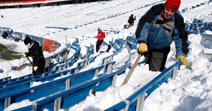
The first big snow of the season threatened to bury towns in New York along lakes Erie and Ontario during a hectic holiday travel and shopping weekend, while winter storm conditions could persist into next week and cause hazards in the Great Lakes, Plains and Midwest regions.
An Arctic outbreak of cold air will expand south and east and bring “dangerously cold wind chills” into the Northern Plains and Upper Midwest, the National Weather Service said Saturday, while heavy lake-effect snow could make travel “very difficult to impossible” into next week.
“Temperatures will be 15 to 20 degrees below average over parts of the Northern Plains and temperatures will be about 10 degrees below average over parts of the eastern third of the country,” the weather service reported.
Cold weather advisories were issued for parts of North Dakota on Saturday and high pressure from central Canada will move south into the Northern Plains by Monday. A freeze warning will be issued over the Central Gulf Coast states to the Southeast, the weather service said.
Light to moderate snow was expected from the middle Mississippi Valley to the central Appalachians on Saturday, with similar snow conditions over parts of the Northern Plains and upper Mississippi Valley and central Appalachians on Sunday, the weather service said.
In Michigan, heavy lake-effect snow in northern parts of the state was expected to continue into the weekend, according to the National Weather Service in Gaylord. Some areas of the Upper Peninsula could see up to 3 feet (0.9 meters) of snow Sunday night through to Monday, National Weather Service meteorologist Lily Chapman said.

As flakes began flying Friday, New York state forecasters warned 4 to 6 feet (1.2 to 1.8 meters) of blowing and drifting snow could fall in Watertown and other areas east of Lake Ontario through Monday.

Get breaking National news
For news impacting Canada and around the world, sign up for breaking news alerts delivered directly to you when they happen.
After an unusually mild fall, as much as two-to-three feet (0.6 to 0.9 meters) of snow were possible along Lake Erie and south of Buffalo from lake-effect bands notorious for pummeling the region with snowfall rates of two-to-four inches (five-to-10 centimetres) per hour. Lake-effect snow happens when warm moist air rising from a body of water mixes with cold dry air overhead.
“The lake is 50 degrees (10 degrees Celsius). We’re about six degrees above where we should be this time of year, that’s why we’re seeing these heavy lake-effect events,” Erie County Public Works Commissioner William Geary said. “The outlook for the next two weeks into December, we’ll probably see some more.”
New York Gov. Kathy Hochul declared a disaster emergency for the targeted counties, allowing state agencies to mobilize resources. Rapidly deteriorating conditions Friday caused closures along Interstate 90, and tandem and commercial vehicles were banned from Interstate 86 in western New York and much of U.S. Route 219 beginning Friday afternoon.
“There’s a considerable number of vehicles going off the road on the 219 currently,” Gregory Butcher, Erie County deputy director for preparedness and homeland security, said at an afternoon briefing.
ATVs and snowmobiles were being placed around the county to help first responders if necessary, Butcher said.
The Buffalo Bills called for volunteers to potentially shovel snow at Highmark Stadium, where over 2 feet (0.6 meters) of snow was possible before Sunday night’s game against the San Francisco 49ers. Last year, a major lake-effect storm forced the NFL to push back the Bills wild-card playoff home game against Pittsburgh from Sunday to Monday.
“It’s going to be slow going, there’s no doubt about that,” Erie County Executive Mark Poloncarz said, adding the heaviest snow is expected to be over by kickoff.
https://x.com/BuffaloBills/status/1862585596390043814
The team, meanwhile, was preparing to play in any conditions.
“We’re trying to stay on top of it,” coach Sean McDermott said Friday.
The Bills are 9-2, their best start since 1992, and with a win Sunday they would clinch their fifth straight AFC East title.
Lake-effect snow also covered parts of Michigan’s Upper Peninsula in a system that is expected to last through the weekend. The area was blanketed in snow by Friday afternoon, with some places already measuring more than a foot (0.3 meters) of snow.
“We’ve got this westerly, northwesterly flow regime and this chilly air mass over the U.P.,” said Chapman of the National Weather Service. “So it’s a pretty good setup for this long duration lake-effect snowfall event.”
Gusty winds, especially near the Great Lakes, has impacted visibility in Michigan and Chapman urged caution on the roads.
Joe DeLizio, a meteorologist for the National Weather Service in Gaylord, said visibility on roads was low but he hadn’t been made aware of any major accidents so far.
“Haven’t heard too much as far as problems, but obviously travel is pretty difficult,” DeLizio said.
© 2024 The Canadian Press


