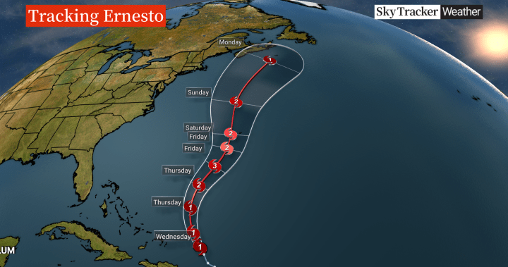
Atlantic Canadians are keeping a close eye on Ernesto, after the storm strengthened into a category 1 hurricane on its path to Bermuda.
As of Wednesday afternoon, Ernesto had already brought torrential rain and high winds to Puerto Rico and the Virgin Islands, and is expected to become a major category 3 storm in the coming days.
Global Meteorologist Ross Hull says the storm will be closer to Canadian waters likely early next week.
“There’s still uncertainty over the exact track — some computer models are showing the centre of the storm moving closer to the Maritimes and Atlantic Canada, others are having the storm move farther east with less of an impact on land,” he said.
He adds there will likely be some weakening as it moves into Canadian waters, but current conditions could affect its intensity.
“Ocean water temperatures are running warmer than average around the Maritimes and Atlantic Canada. which could help maintain some of the storm’s intensity,” Hull said.
An enhanced satellite image of Ernesto as of Aug. 14, 2024.
Global News
Chris Fogarty with the Canadian Hurricane Centre says eastern Canada should expect to see some sort of an impact next Monday or Tuesday.
The email you need for the day’s
top news stories from Canada and around the world.

Get daily National news
Get the day’s top news, political, economic, and current affairs headlines, delivered to your inbox once a day.
“We can guarantee you there will be large waves along the coast, Atlantic coast of Nova Scotia and Newfoundland. But we’re not quite sure yet whether we’ll get rain and wind from it. That’s still remains unknown,” he said.
Fogarty says it’s been “quiet here in Atlantic Canada so far this season” in terms of tropical systems, but Ernesto could change all that.
“Ernesto could be the first one that we have to contend with directly,” he said.
“Once we get into early Friday, we’re going to have a pretty good idea by that point which part of the Maritimes will see rain or winds. And it looks like Newfoundland also will be on the edge of it in the Tuesday timeframe.”
Forecasters had predicted this to be an above-normal hurricane season — something Fogarty says has been true so far.
In July, the remnants of post-tropical storm swept through parts of Nova Scotia. The heavy rain caused flash flooding, and claimed the life of a child in Wolfville, N.S., after the youth was pulled into a water-filled ditch.
Just last week, remnants of tropical storm Debby brought record-setting rain to Montreal and battered southern parts of Quebec.
“The forecast for the season in general seems to be playing out, especially with Beryl early in the season. For a category 5 that early (in the calendar year) that’s almost unprecedented,” said Fogarty.
“That was due to the exceptionally warm water in the tropical Atlantic. And with Debby and Beryl also affecting us in Canada … we are already quite well ahead of the mark that we’re used to in mid-August.”

In an update earlier this week, Environment Canada said 17 to 24 named storms are expected to hit Canada by the end of the year — with most of these storms expected to largely affect the Atlantic provinces and Quebec. Of these named storms in 2024, three are expected to be category 3 to 5 hurricanes.
The 30-year average is 14 named storms a year.
Hurricane season officially runs from June through November.
© 2024 Global News, a division of Corus Entertainment Inc.


