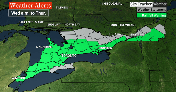
Warnings are in place as the remnants of hurricane Beryl are set to move into parts of Canada, bringing heavy rain and the threat of torrential downpours.
Global News meteorologist Ross Hull said some uncertainty remains on where exactly the heaviest rain will fall, but there is confidence growing that Beryl’s remnants will bring lots of precipitation beginning Wednesday morning for southern Ontario, including the Greater Toronto and Hamilton Area (GTHA).
The system is also expected to affect southern Quebec including Montreal, before moving into parts of the Maritimes.
“The concern is the tropical moisture associated with this system as it moves over the area which will drop torrential rains which could result in localized flooding — especially in urban areas,” Hull said.
Rainfall warnings in place as of around 4 p.m. Tuesday.
Global News
“Rainfall warnings have been issued for a large swath of southern Ontario, including the GTHA, where 40 to 60 mm is possible from early Wednesday to Thursday morning, with some downpours dropping 20 to 40 mm an hour.”
Even higher rain totals of more than 60 mm, possibly up to 100 mm locally, are possible for parts of midwestern Ontario along the shoreline of Lake Huron, as well as parts of eastern Ontario, Hull said.
Beryl, which made landfall in Texas early Monday as a Category 1 hurricane, has been blamed for at least seven U.S. deaths — one in Louisiana and six in Texas — and at least 11 in the Caribbean. At midday Tuesday, it was a post-tropical cyclone centered over Arkansas.
Storm timing
Breaking news from Canada and around the world
sent to your email, as it happens.
For southern Ontario and the Toronto area, the steadiest and heaviest rain from Beryl’s remnants is expected Wednesday morning.
“However, more heavy downpours associated with thunderstorms could occur during the afternoon and evening,” Hull said.
“Ponding and pooling on roadways will be an issue especially for the Wednesday morning commute.”
The chance for heavy rain will diminish by Thursday morning for the region, Hull said.
In southern Quebec and the Montreal area, the heaviest rain is expected to move in by Wednesday afternoon, Hull said, likely having an impact on the evening commute.
He said 30 to 50 mm is expected there, with heavier amounts possible south of the Island of Montreal.
“By Thursday morning, heavy rain will start moving into New Brunswick and parts of Nova Scotia where 30 to 50 mm, locally 50+mm, could fall in some areas,” Hull said.
TRCA issues flood watch
The Toronto and Region Conservation Authority (TRCA) has issued a flood watch ahead of the system’s arrival.
“All shorelines, rivers and streams within the GTA should be considered dangerous as this rainfall will result in higher flows, rapidly changing water levels and unstable river banks,” the watch reads in part.
“Flooding in TRCA watersheds is possible due to forecasted rainfall amounts and rainfall intensities over the next two days….
“There is the potential for widespread flooding within the TRCA jurisdiction Wednesday and Thursday due to thunderstorm activity and the forecasted rainfall amounts from remnants of Hurricane Beryl. There is also potential for some locations within TRCA to receive over 50mm of rain in a short period of time, leading to localized flooding.”
The TRCA encouraged the public to stay away from rivers, streams and shorelines and to avoid recreational activities in or around water.
It also encouraged people to allow for more time when commuting and said to avoid driving through flooded roadways.
When Beryl made landfall in Texas, it was far less powerful than the Category 5 behemoth that tore a deadly path through parts of Mexico and the Caribbean. But its winds and rains still knocked down hundreds of trees that had already been teetering in saturated earth and stranded dozens of cars on flooded roads.
Beryl was the earliest storm to develop into a Category 5 in the Atlantic.
— With files from The Associated Press
© 2024 Global News, a division of Corus Entertainment Inc.


